

Vancouver, B.C., May 3, 2022. Northstar Gold Corp. (CSE:NSG, NSGCF:OTCQB) (“Northstar” or the “Company”), announces the Company has signed an Option Agreement (or “the Agreement”) to acquire 100% interest in the 161 hectare Britcanna Property Mining Lease (or “the Property”) situated 47 km south of Kirkland Lake, Ontario.
“The Britcanna Mining Lease Option Agreement provides for the strategic acquisition of a number of porphyry-hosted, historic high-grade gold zones and occurrences that compliment Northstar’s Bryce Gold Property,” states Brian Fowler, P.Geo., President, CEO and Director of Northstar. “This Agreement further consolidates Northstar’s ownership of the Britcanna Porphyry, which is highly prospective for high-grade and low-grade bulk tonnage gold mineralization. Northstar is formulating plans to advance the Britcanna and Bryce Gold Properties by way of surface mapping, trenching, sampling and diamond drilling.”
Britcanna Property
The historic Britcanna Property is encompassed by Northstar’s Bryce Gold Property and is host to lode gold, volcanogenic polymetallic sulphides and porphyry-related Au-Cu stockwork-type mineralization within the Britcanna Porphyry intrusive stock (Figure 1). The Britcanna Porphyry is cut by several late-stage lamprophyric alkaline dikes which are typically associated with deep seated crustal scale regional structures such as the PVE break that transects the northern portion of Northstar’s Bryce Gold Property and hosts numerous gold showings. Approximately 4,400 metres of shallow drilling in 69 historic drill holes was completed on the Property by several operators between 1936 and 1998.
Multiple gold zones have been explored on the Property as early as 1937, with historic high grade drill intercepts in the No.1 Zone of 170 g/t Au over 1.1 metres and 45.9 g/t Au over 1.5 metres in Britcana Gold Mines Hole No.3 and 30.2 g/t Au over 1.5 metres and 38.7 g/t Au over 1.5 metres in Britcanna Gold Mines Hole No.5.** The No.1 Zone is a porphyry-hosted silicified shear zone containing pyrite and chalcopyrite mineralization over a strike length of 50 to 75 metres and a vertical depth of 40 metres. Remnants of a nearby two-compartment shaft sunk to explore the No. 1 Zone underground are still evident (Figure 2).
The No.2 Zone, located 900 metres southwest of the No.1 Zone is comprised of heavy disseminated sulphides (including chalcopyrite) within a 2 metre-wide shear zone along a contact between mafic volcanic flows and intermediate tuff. Historic drilling intercepts in No.2 Zone include 10.4 g/t Au over 1.5 metres and 15.1 g/t Au over 0.6 metres at a vertical depth of 90 metres,** with the Zone apparently expanding at depth. A 20 tonne bulk sample collected in 1937 by Britcanna Gold Mines from a surface trench on the No.2 Zone and shipped to Noranda reportedly graded 41 g/t Au* (Figure 2). More recent sampling of massive pyrite collected by Norite Exploration from a surface trench on the No.2 Zone assayed 40.7 g/t Au over 0.3 metres with a grab sample by E.E. Campbell from the same trench grading 123g/t Au.***
Drilling on the No.5 Zone, located 250 metres southeast of the No.1 Zone by Novawest Resources in 1998 produced broad low-grade gold intercepts in a porphyry hosted quartz stockwork that includes 1.85 g/t Au over 5.83 metres from 43.22 metres to 49.05 metres, including 7.04 g/t Au over 1.03 metres in hole GV98-03.****
Sampling by Gold Fields Canadian Mining in 1990 on the nearby No.6 Zone yielded a sample assaying 98.4 g/t Au over 0.15 metres. Follow up Novawest drill hole GV98-04 reportedly intersected 3.54 g/t Au over 1.1 metres from 36.57 metres to 37.67 metres with reported visible gold.**** Novawest drill hole GV-98-07, drilled norward towards the No.6 Zone intersected a previously unidentified, thick cherty exhalite with the presence of banded/bedded sulphides (pyrite-pyrrhotite-sphalerite and minor chalcopyrite) within the hanging wall volcanics south of the No.6 Zone.****
* Johns, G.W. 1986: Geology of the Hill Lake Area, District of Timiskaming; Ontario Geological Survey Report 250, 100p.
** Ontario Ministry of Energy, Northern Development and Mines Assessment Report #CO-0193: "Britcanna Gold Mines – International Bulletin, February 1, 1937" by J.C Houston M.E., Consulting Mining Engineer. Resident Geologist's Files, Ontario Ministry of Energy, Northern Development and Mines, Kirkland Lake, Ontario
*** Ontario Ministry of Energy, Northern Development and Mines and Mines Assessment Report #CO-0195: Report on Norite Explorations Limited Bryce Township District of Temiskaming, Ontario, June 3, 1965, by L.J. Cunningham, BSc. P.Eng, Mining Engineer
****Novawest Resources (VSE:NVE) Press Release dated June 26, 1998.
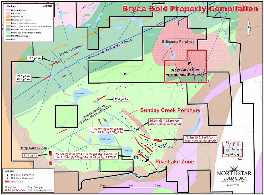
Figure 1. Bryce Gold Property Compilation Map with Britcanna Property
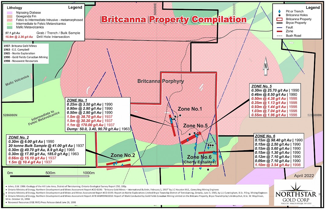 Figure 2. Britcanna Property Compilation Map
Britcanna Property Agreement Terms
To earn a 100% interest in the Britcanna Property, Northstar has agreed to the following option terms (All dollar amounts in CAD unless specified otherwise):
- Cash payment of $18,000 and issuance of $15,000 in Northstar common shares upon signing.
- On the first anniversary date of the Agreement, issue $20,000 of Common Shares of Northstar to the Vendors and pay to the Vendors $20,000;
- On the second anniversary date of the Agreement, issue $35,000 of Common Shares to the Vendors and pay to the Vendors $22,000; and
- On the third anniversary date of the Agreement, issue $30,000 of Common Shares to the Vendors and pay to the Vendors $25,000 for a 100% interest in the Property.
- Northstar shall pay to the Vendors an annual advance minimum royalty (“AMR”) payment of $5,000 per year for a period of 10 years once 100% of the Option has been exercised. The Parties acknowledge that any AMR payments shall be credited in favour of Northstar against any future Royalty payments to the Vendors.
- The Vendors retain a 2.0% Net Smelter Return (NSR). Northstar has the right to purchase 1% of the NSR for $1.0 million and retains a standard right of first refusal on any proposed sale or transfer by Vendors of the remaining 1% of the NSR.
Bryce 43-101 Technical Report
The Company has recently completed an Independent NI43-101 Technical Report for its Bryce Gold Property (“Property”) located 47 kilometres south of Kirkland Lake in Northeastern Ontario. Northstar commissioned Ronacher McKenzie Geoscience (“Ronacher McKenzie”) to complete the report for the purpose of review and voluntary disclosure of relevant information about the Property following a recent airborne LiDAR survey and Fall 2021 surface exploration program covering the Bryce Gold Property (Northstar Gold Corp.- News Release dated April 26, 2022).
Bryce Gold Property Highlights
- 100% owned, 4,650-hectare property situated on the western extension of the Ridout Break, 65 km east of the Juby Gold Project and 35 kilometres south of Northstar’s flagship Miller Gold Property.
- Property hosts a variety of deposit types including porphyry related Au-Cu (Sunday Creek Porphyry), Au-rich Cu-Pb-Zn volcanogenic massive sulphides (Pike Lake Zone) and lode gold systems within an Abitibi multi-stage Archean porphyry / volcanic centre environment.
- 22,382 metres drilled by Northstar in 68 diamond drill holes from 5 phases of drilling between 2009 and 2013, covering only a small fraction of the total Property area.
- 300 metre x 1500 metre Au-Cu Sunday Creek Porphyry (Figure 1) discovery hosts a large scale stockwork-type Au-Cu porphyry system with widespread stringers and veins of high-grade gold mineralization open in all directions and expanding towards surface. Drill holes BG10-41 and BG12-65 returned 3.95 g/t Au over 5.5m, including 12.91 g/t Au over 1.5m and 0.86 g/t Au over 80 metres (including 2.09 g/t Au over 25.5 metres), respectively and drill hole BG13-68 averaged 1.08 g/t Au over 56 metres (including 25.13 g/t Au over 2.0 metres).
- The nearby Pike Lake Zone (Figure 1) hosts a series of stacked lenses of gold-bearing semi-massive pyrite and sphalerite along a volcanogenic sedimentary exhalite horizon. Drill hole intercepts include 2.36 g/t Au, 3.37 g/t Ag and 1.87% Zn over 15.9 metres, including 7.89 g/t Au, 11.18 g/t Ag and 3.77% Zn over 2.4 metres (DDH BG11-47).
- Regional fault structures such as the Palmer-Vaughn-Estival “PVE” break hosting anomalous gold have been identified on surface, which could represent the eastern extension of the Ridout deformation zone.
- Several large IP targets and conductors remain untested.
- Potential for substantial near surface bulk tonnage gold resources around felsic intrusive centers.
- Several major, northeast-trending structures were interpreted from a 2021 LiDAR survey and magnetic survey in the northern and western part of the Property. Follow-up prospecting, sampling and mapping along the major northeast-trending fault (“PVE Fault”) and splays is warranted.
- A $528,500 exploration program including geological modeling, incorporating property-wide historic and Northstar geological data, and diamond drilling on the Sunday Creek and Pike Lake areas to further assess gold-bearing zones is recommended by Technical Report QP Trevor Boyd, PhD., P.Geo.
- Northstar is considering opportunities to advance the Bryce Gold Property by way of earn-in agreement or spin-out transaction.
- The Bryce Gold Property NI43-101 Technical Report can be viewed on Northstar’s website and SEDAR.
Qualified Person
Trevor Boyd, PhD, P.Geo., a ‘Qualified Person’ (Q.P.) as defined under Canadian National Instrument NI 43-101, has reviewed technical aspects of this news release.
About Northstar Gold Corp
Northstar’s primary exploration focus is the advancement of the Company’s flagship, 100%-owned Miller Gold Property, situated 18 km southeast of Kirkland Lake and Agnico Eagle Mine’s Macassa SMC gold mine. The Company’s strategy is to develop a material (+1 million ounce) mineral resource base to support a stand-alone mining operation at the Miller Gold Property.
The Miller Gold Property shares several important geological similarities with Kirkland Lake District gold deposits, including a similar style and age of gold-telluride mineralization, similar aged rocks and interconnected First Order controlling structures (Catharine Fault at Miller) off the Kirkland / Cadillac Larder Breaks. The premise is that gold-telluride mineralization at the Miller Gold Property is tapping the same magmatic gold source as the Kirkland gold deposits, which have produced over 25 million ounces of gold from 7 mines over the past 100 years.
Since going public by IPO in late 2020, Northstar has spent >$4 million in exploration at Miller, resulting in the discovery of a series of broad, shallow dipping sheeted quartz-gold-telluride vein structures in the Allied Syenite (Allied Syenite Gold Zone) and Planet Syenites and numerous +100 gram/metre drill hole intercepts.
During the period of August 7th – November 4th, 2021, Northstar completed an enhanced surface stripping, mapping and sampling program targeting near-surface gold mineralization over the Allied Syenite, No. 1 Vein and other areas on the Miller and recently acquired adjoining Searles Patent. In November, 2021 the Company announced the completion of a 14-hole, 2,495 metre Phase IIB diamond drill program at Miller targeting expansions of the Allied Gold Zone, twinning a number of historic No. 1 Vein drill holes on the Searles Patent and drill testing the newly discovered Area E mineralized zone 450 metres west of the Allied Syenite.
Recent 2021 drilling has more than doubled the surface expression (>350m X 200m) of the Allied Syenite Gold Zone, which remains open along strike and at depth. As a precursor to a Mineral Resource Estimate and for reporting purposes, the Company has commenced work to formally document the Allied Syenite Gold Zone as an Exploration Target in Q2 2022. This will provide the Company and investors a conceptual tonnage and gold grade range at the Allied Syenite Gold Zone and provide basis for continued expansion drilling and mineral resource development.
Northstar has 3 additional 100%-owned exploration projects in northern Ontario, including the recently acquired 1,200 ha Rosegrove Property situated 0.5 km from the Miller Gold Property, the 4,650 ha Bryce Gold Property, an intrusive-gold / PME VMS project located along the projected east extension of the Ridout Break, and the recently expanded Temagami-Milestone Cu-Ni-Co Property located in Strathcona Township. Northstar recently filed a NI43-101 Technical Report on the Bryce Gold Property and is advancing all 3 properties to enhance geological understanding and optimize monetization opportunities.
On behalf of the Board of Directors,
Mr. Brian P. Fowler, P.Geo.
President, CEO and Director
(604) 617-8191
bfowler@northstargoldcorp.com
Cautionary Note Regarding Forward-Looking Statements
This news release contains certain forward looking statements which involve known and unknown risks, delays, and uncertainties not under the control of Northstar Goldcorp. which may cause actual results, performance or achievements of Northstar Gold Corp to be materially different from the results, performance or expectation implied by these forward looking statements. By their nature, forward looking statements involve risk and uncertainties because they relate to events and depend on factors that will or may occur in the future. Actual results may vary depending upon exploration activities, industry production, commodity demand and pricing, currency exchange rates, and, but not limited to, general economic factors.
