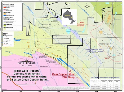
Vancouver, B.C., November 16, 2023. Northstar Gold Corp. (CSE:NSG, OTC:NSGCF) (“Northstar” or the “Company”), announces preliminary results from a Phase I diamond drill program at the historic Cam Copper Mine, a small-scale, former high-grade copper producer on the Company’s 100%-owned Miller Copper-Gold Property, situated 18 kilometres southeast of Kirkland Lake, Ontario. The Cam Copper Mine is a road accessible satellite high-grade volcanogenic massive sulphide (VMS) copper system situated 2.4 km southwest of the Allied Gold Zone, the advanced, near-surface bulk-tonnage alkalic gold-telluride exploration target also being actively explored by Northstar. Cam Copper Mine occupies the southern portion of the historic Boston Creek Copper Trend (Figure 1).
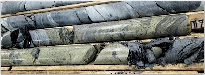
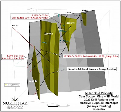
Northstar completed 720 metres of drilling in 4 diamond drill holes (CC01-23 to CC04-23 – Figure 2) at Cam Copper Mine between October 20th and October 30th, 2023. The Company reports all 4 drill holes intersected lenses of Cu-rich volcanogenic massive sulphides, including massive and stringer chalcopyrite over 2.45m in drill hole CC03-23 between 116.55m to 119m in Zone 2 (Photos 1 and 2). A 3D Cam Copper Mine image illustrating Phase I drill results and massive sulphide intercepts is provided in Figure 2. Analytical results for drill holes CC02-23 to CC04-24 are pending and expected shortly.
The Company reports the following assay results received from drill hole CC01-23 (Photo 3):
- 3.12% Cu over 3.6m from 25.0m to 28.6m including 19.45% Cu and 14.85 g/t Ag over 0.5m from 28.1m to 28.6m in Zone 1 (Photo 3)
- 12.71% Cu, 0.62% Zn, 0.44% Pb, 16.47 g/t Ag over 0.75m from 107m to 107.75m in Zone 2
- 5.91% Cu over 1.5m from 135.0m to 136.5m including 9.92% Cu over 0.5m from 135.5m to 136m in Zone 3
Massive sulphides were intersected in Zone 2 well below the 200’ level of the historic mine workings at 130m vertical depth in drill hole CC02-23. Zone 2 appears to be expanding in thickness down plunge towards the southeast, and all zones remain open along strike and at depth.

Figure 1. Miller Property Geology (West Half) Highlighting Former Producing Mines along the Boston Creek Copper Trend

Photo 1. Massive chalcopyrite from Zone 2 in DDH CC03-23

Photo 2. Zone 2 massive and stringer chalcopyrite between 116.55m and 119m in DDH CC03-23
 Photo 3. Zone 1 massive chalcopyrite from DDH CC01-23 grading 19.45% Cu over 0.5m
Table 1. Drill Hole CC01-23 Assay Results

Management Commentary
“Northstar’s 2023 sampling and preliminary Phase I drill results substantiate the presence of a robust, multi-horizon high-grade copper VMS system at Cam Copper Mine, exhibiting excellent expansion potential”, states Brian P. Fowler, P.Geo., Northstar’s President, CEO and Director. “Northstar is fully permitted and positioning to explore the southeast strike and down plunge extensions of the Cam Copper massive sulphide zones through Phase II drilling.”

Figure 2. Cam Copper Mine 3D Model – 2023 Preliminary Phase 1 Drill Results And Massive Sulphide Intercepts (Assays Pending)
Southeast Extension – Geophysical Targets
Volcanic exhalite mineralization consisting of massive or semi-massive pyrite is known to extend for hundreds of metres along strike southeast of the Cam Copper Mine site, having been previously explored by historic pitting and trenching. The copper trend includes multiple historic ground EM and IP bedrock targets3 along with strong airborne EM and magnetic anomalies which could highlight conductive bedrock targets such as Cu-rich massive sulphides for up to 900 metres along strike to the southeast.
Future Plans
After receipt of all Phase I drill results, Northstar will position to conduct a Phase II Cam Copper drill program to test the down plunge extension of mineralized zones, prioritizing expansion of the Zone 2 massive sulphide lens and stockwork intersected in DDH CC03-23.
Owing to the conductive and chargeable nature of the massive sulphide mineralization encountered at Cam Copper, a program of surface and borehole geophysics is also being planned to survey the mine site area and the Boston Creek copper trend along strike towards the southeast.
Cam Copper Geology
Cam Copper Mine copper mineralization is hosted in the oldest known and possibly least understood lithological assemblage in the Abitibi Greenstone Belt known as the Pacaud assemblage or Pacaud “Tuffs” (circa 2750 Ma; 2750Ma-2735Ma volcanic episode). The Pacaud assemblage is composed of finely bedded and intercalated mafic, intermediate, and felsic ash-tuff intruded by mafic sills. Sulphide mineralization appears to be stratiform and volcanogenic in nature with the zones exhibiting a distinctive stockwork feeder system in the footwall with chalcopyrite, pyrrhotite and magnetite stringers (+/-pyrite) and a massive chalcopyrite cap or lens stratigraphically above the underlying stockwork. Minor sphalerite and galena appear in the uppermost part of the sulphide cap.
Massive bornite “pods” were reported historically. Multiple stacked VMS horizons with significant sheet-like lateral and vertical extent, hosted in volcano-sedimentary rock packages are characteristic of Besshi-type or Pelitic-Mafic/Mafic-Siliciclastic (NRCAN nomenclature) VMS deposits. These deposits, while known to exist in the Archean, are typically more common in Phanerozoic terrains. The VMS lenses at the Cam Copper Mine remain open in all directions, particularly down plunge to the southeast. The former producing Amity and Patterson copper mines occur within the same geologic formation along strike to the northwest.
Northstar carried out a brief surface exploration program consisting of prospecting and sampling of Cam Copper Mine between May 19 and 25th, 2023. A total of 19 representative surface grab samples were collected from the muck pile and bedrock surface near the historic shaft. Three samples were collected from a historic trench along the surface expression of Zone 2. Assay results of the 19 samples ranged from 0.99% – 31.8% Cu, and 0.31 g/t Ag - 452 g/t Ag. Copper grades from the Cam Copper muck pile and bedrock were consistent with historically reported grades from both drilling intercepts, underground sampling and former mine production data.
One muck sample (E455292) of massive chalcopyrite with bornite assayed 31.8% Cu, 0.53% Zn, and 452 g/t Ag. A bedrock sample (E455309) collected from mineralized stratiform sulphides near the historic shaft assayed 13.65% Cu.
Three samples collected from a trench representing the surface expression of Zone 2 included one sample (E455315) that assayed 0.54% Cu, indicating a possible extension of Zone 2 towards the southeast of the old workings.
Follow up work is required in the Cam Copper area to fully investigate the down plunge extension of the historic deposit.
Underground Development and Historic Copper Production
The Cam Copper Mine hosts at least three separate lenses (Zone 1, Zone 2, Zone 3 and a possible Zone 4– Figure 2) of massive copper sulphides about 30-50 metres apart striking and plunging southeast along the contact with the Round Lake Granite Batholith. Underground development took place between 1929 and 1953 which included sinking a 220’ (66.7m) vertical shaft with 213’ (64.5m) of cross cuts and 267’ (80.9m) of drifts. The recent drilling and surface sampling results substantiate historic copper grades reported in a 1955 shipment of 346 tons of hoisted underground ore that produced 43,411 lbs. of Cu1 at a Noranda smelter, for a recovered grade of 6.3% Cu. The ore was shipped directly from the mine site to the smelter without requiring further concentration in a mill. A previous 1948 shipment of 22 tons of ore to Noranda reportedly graded 12.72% Cu, 0.84 oz/t Ag and 0.03 oz/t Au2, presumably from Zone 1.
Historic Drilling
Historic drilling intercepts in Zone 1 by Consolidated Golden Arrow Mines Ltd. at the Cam Copper Mine include: 3
- 1.6% Cu over 6.6’ (2.0m) in DDH 1
- 9.8% Cu over 4’ (1.21m) in DDH 1A
- 12.4 % Cu over 7.8’ (2.36m) in DDH 3
- 7.0% Cu over 6’ (1.82m) in DDH 4
Average sampling grade reported in Zone 1 was 8.5% Cu over a true width of 4.4’ (1.33m) indicated over 100’ (30.3m) along strike.
Historic drilling intercepts by Consolidated Golden Arrow Mines Ltd. in Zone 2 include: 3
- 10.5% Cu over 0.5’ (0.15m) in DDH 2
- 19.9% Cu over 3.1’ (0.94m) in DDH 3
- 23.1% Cu over 4.6’ (1.39m) in DDH 4 ---> down plunge extension below workings
- 12.4% Cu over 3.3’ (1.0m) in DDH 7 ---> down plunge extension below workings
Average sampling grade reported in Zone 2 was 10% Cu over a true width of 2.8’ (0.85m) indicated over 140’ (42.4m) along strike.
Bornite was reported to be common in Zone 2 with the bornite rich pods of massive sulphides remaining open down plunge to the southeast.3
1 Ontario Ministry of Energy, Northern Development and Mines Mineral Deposit Inventory Record MDI31M13NW000154: Tretheway-Ossian- 1981, Ch.H. Cameron-1981.
2 Ontario Ministry of Energy, Northern Development and Mines and Mines Assessment File #KL-0259, Tretheway-Ossian (Cam Copper Mine). 1961
3 Ontario Ministry of Energy, Northern Development and Mines and Mines Assessment File #KL-0843, Prospectus of Fidelity Mining Investments Ltd. 1962
Quality Control
Samples collected in the 2023 Miller surface exploration and drilling programs were delivered to ALS Global in Timmins, Ontario for preparation and assayed for gold and other elements by ALS Global in Vancouver, British Columbia.
Northstar has implemented a quality control program for its Cam Copper Project to ensure best practice in the sampling and analysis of surface samples, which includes the insertion of blanks, and certified standards into the sample stream.
Surface samples were submitted to ALS Global at their Timmins, Ontario facility for sample preparation where the entire sample was crushed to better than 90% passing 2mm, 1000g riffle split and pulverized to 85% passing 75 microns. Pulps are forwarded to ALS Global in Vancouver, British Columbia for analyses. Gold analyses is obtained via industry standard fire assay with ICP finish using 15 g to 30 g aliquots. For samples returning greater than 10 g/t gold follow-up fire assay analysis with a gravimetric finish is completed. Based on initial fire assay gold indications as well as visual indication of mineralization and alteration, samples are selected for re-assay by the screen metallic fire assay method. Samples are also analyzed for 48 trace and major elements by ICP-MS following a four-acid digestion. For samples returning greater than 10,000 ppm Cu, follow-up four acid digestion and ICP finish utilizing a 0.4 g sample is utilized. ALS Global are ISO/IEC 17025:2017 accredited (Lab No. 579) for the preparation and analyses performed on the Milestone samples.
Qualified Person
John Siriunas, P.Eng., a ‘Qualified Person’ (Q.P.) as defined under Canadian National Instrument NI 43-101, has reviewed technical aspects of this news release.
About the Miller Property
Northstar’s primary exploration focus is the advancement of the Company’s flagship, 100%-owned Miller Gold Property, situated 18 km southeast of Kirkland Lake and Agnico Eagle Mine’s Macassa SMC gold mine. The Company’s strategy is to develop either a minimum material (+1 million ounce) high-grade gold mineral resource to potentially supplement a nearby mining operation or a stand-alone mining operation at the Miller Gold Property.
Since going public by IPO in late 2020, Northstar has spent over $4.7 million in exploration at Miller, resulting in the discovery of a series of broad, near-surface, shallow dipping sheeted quartz-gold-telluride vein structures in the Allied Syenite (Allied Gold Zone) and Planet Syenites and numerous 70 – 750 gold gram/metre drill hole intercepts. Drilling to date at the AGZ has returned near-surface gold intercepts that include 6.6 g/t Au over 117.0 metres, 4.0 g/t Au over 50.6 metres, 1.4 g/t Au over 118.5 metres, and 1.2 g/t Au over 107.3 metres. Step out AGZ drilling in 2021 intersected peripheral steeply dipping copper-gold bearing structures (CG1 and CG2 Zones) returning intercepts that include 9.41 g/t Au, 1.03% Cu over 3.0m. The AGZ shares numerous compelling similarities to Agnico Eagle’s nearby Upper Beaver Deposit, currently in the pre-development stage.
In April, 2022, as a precursor to a Mineral Resource Estimate and for reporting purposes, the Company commissioned Ronacher Mackenzie Geoscience and SRK Consulting (Canada) to conduct an Exploration Target Study of the Miller Property Allied Gold Zone and No. 1 Vein. An upper range exceeding 500,000 ounces of gold averaging 2.04 g/t Au has been referenced in this study. Results were reported July 26, 2022, (Click here to view Northstar News Release dated July 26, 2022) verifying the significance, size and gold grade potential of the Allied gold mineralizing system. Results provide the Company and investors a fact-based conceptual tonnage and gold grade range for the Allied Syenite Gold Zone, and basis for continued expansion drilling and mineral resource development.
In addition to drill testing extensions of the high-grade Cam Copper Mine, Northstar is positioning to conduct a Phase IIIA Allied Gold Zone lateral and depth expansion drill program on the Miller Gold Property.
Northstar has 3 additional 100%-owned exploration projects in northern Ontario, including the recently acquired 1,200 ha Rosegrove Property situated 0.5 km from the Miller Gold Property, the 4,650 ha Bryce Gold Property (includes the recently optioned Britcanna Lease), an intrusive-gold / PME VMS project located along the projected east extension of the Ridout Break, and the recently expanded Temagami-Milestone Cu-Ni-Co Critical Minerals Property located in Strathcona Township. Northstar is advancing all 3 properties to enhance monetization opportunities.
About Northstar Gold Corp.
Northstar’s primary exploration focus is the advancement of the Company’s flagship, 100%-owned Miller Gold Property, situated 18 km southeast of Kirkland Lake and Agnico Eagle Mine’s Macassa SMC gold mine. The Company’s strategy is to develop either a minimum material (+1 million ounce) high-grade gold mineral resource to potentially supplement a nearby mining operation or a stand-alone mining operation at the Miller Gold Property.
Northstar has 3 additional 100%-owned exploration projects in northern Ontario, including the recently acquired 1,200 ha Rosegrove Property situated 0.5 km from the Miller Gold Property, the 4,650 ha Bryce Gold Property (includes the recently optioned Britcanna Lease), an intrusive-gold / PME VMS project located along the projected east extension of the Ridout Break, and the recently expanded Temagami-Milestone Cu-Ni-Co Property located in Strathcona Township. Northstar recently filed a NI43-101 Technical Report on the Bryce Gold Property and is advancing all 3 properties to enhance monetization opportunities.
On behalf of the Board of Directors,
Mr. Brian P. Fowler, P.Geo.
President, CEO and Director
(604) 617-8191
Connect with us on Twitter | LinkedIn | Instagram
Neither the Canadian Securities Exchange nor its Regulation Services Provider accepts responsibility for the adequacy or accuracy of this release.
Cautionary Note Regarding Forward-Looking Statements
This news release contains certain forward looking statements which involve known and unknown risks, delays, and uncertainties not under the control of Northstar Goldcorp. which may cause actual results, performance or achievements of Northstar Gold Corp to be materially different from the results, performance or expectation implied by these forward looking statements. By their nature, forward looking statements involve risk and uncertainties because they relate to events and depend on factors that will or may occur in the future. Actual results may vary depending upon exploration activities, industry production, commodity demand and pricing, currency exchange rates, and, but not limited to, general economic factors.


