Vancouver, B.C., April 26, 2022. Northstar Gold Corp. (CSE:NSG, NSGCF:OTCQB) (“Northstar” or the “Company”), announces the Company has completed an Independent NI43-101 Technical Report for its Bryce Gold Property (“Property”) located 47 kilometres south of Kirkland Lake in Northeastern Ontario. Northstar commissioned Ronacher McKenzie Geoscience (“Ronacher McKenzie”) to complete the report for the purpose of review and voluntary disclosure of relevant information about the Property following a recent airborne LiDAR survey and Fall 2021 surface exploration program covering the Bryce Gold Property.
Bryce Gold Property Highlights
- 100% owned, 4,650-hectare property situated on the western extension of the Ridout Break, 65 km east of the Juby Gold Project, 50 km southeast of the Young Davidson Mine (Figure 1) and 35 kilometres south of Northstar’s flagship Miller Gold Property.
- Property hosts a variety of deposit types including porphyry related Au-Cu (Sunday Creek Porphyry), Au-rich Cu-Pb-Zn volcanogenic massive sulphides (Pike Lake Zone) and lode gold systems within an Abitibi multi-stage Archean porphyry / volcanic centre environment.
- 22,382 metres drilled by Northstar in 68 diamond drill holes from 5 phases of drilling between 2009 and 2013, covering only a small fraction of the total Property area.
- 300 metre x 1500 metre Au-Cu Sunday Creek Porphyry discovery hosts a large scale stockwork-type Au-Cu porphyry system with widespread stringers and veins of high-grade gold mineralization open in all directions and expanding towards surface. Drill holes BG10-41 and BG12-65 returned 3.95 g/t Au over 5.5 metres, including 12.91 g/t Au over 1.5 metres and 0.86 g/t Au over 80 metres (including 2.09 g/t Au over 25.5 metres), respectively and drill hole BG13-68 averaged 1.08 g/t Au over 56 metres (including 25.13 g/t Au over 2.0 metres).
- The nearby Pike Lake Zone (Figure 2) hosts a series of stacked lenses of gold-bearing semi-massive pyrite and sphalerite along a volcanogenic sedimentary exhalite horizon. Drill hole intercepts include 2.36 g/t Au, 3.37 g/t Ag and 1.87% Zn over 15.9 metres, including 7.89 g/t Au, 11.18 g/t Ag and 3.77% Zn over 2.4 metres (DDH BG11-47).
- Regional fault structures such as the Palmer-Vaughn-Estival “PVE” break hosting anomalous gold have been identified on surface, which could represent the eastern extension of the Ridout deformation zone.
- Several large IP targets and conductors remain untested.
- Potential for substantial near surface bulk tonnage gold resources around felsic intrusive centers.
- Several major, northeast-trending structures were interpreted from a 2021 LiDAR survey and magnetic survey in the northern and western part of the Property. Follow-up prospecting, sampling and mapping along the major northeast-trending fault (“PVE Fault”) and splays is warranted.
- A $528,500 exploration program including geological modeling, incorporating property-wide historic and Northstar geological data, and diamond drilling on the Sunday Creek and Pike Lake areas to further assess gold-bearing zones is recommended by Technical Report QP Trevor Boyd, PhD., P.Geo.
- Northstar’s options to advance the Bryce Gold Property include a possible earn-in agreement or spin-out transaction.
- The Bryce Gold Property NI43-101 Technical Report can be viewed on Northstar’s website and is filed on SEDAR.
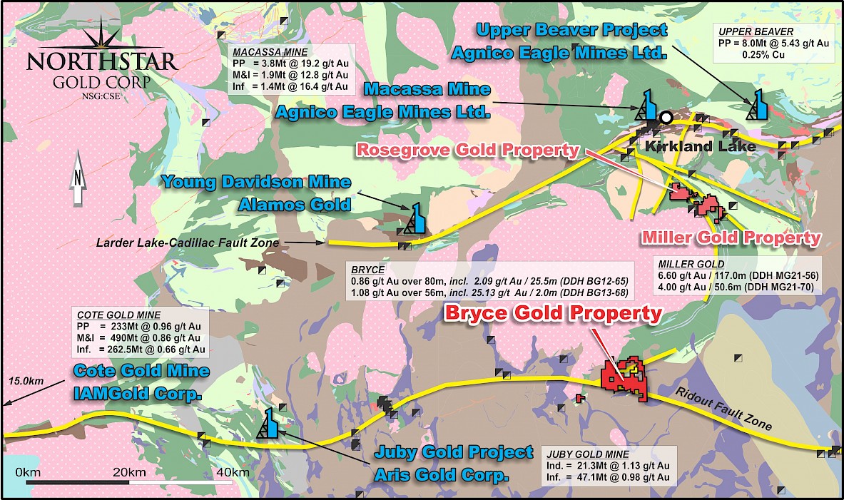
Figure 1. Regional Geology of the Bryce Gold Property Area
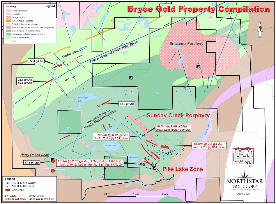
Figure 2. Bryce Gold Property Compilation Map
2021 Surface Exploration Program
Northstar completed a geological mapping program on the Bryce Gold Property in September and October, 2021. Mapping was focused on the area between Honeymoon Lake and southeast of Pike Lake (Figure 3), with a focus to enhance volcanic stratigraphy understanding, determine surface locations of porphyry dikes and bodies, and identify prospective deformation zones.
The main rock types observed were intermediate volcanic rocks that display great variability from massive flows and pillowed flows to hyaloclastites, flow breccias, amygdaloidal flows and tuffs, lapilli tuffs, tuff breccias and pyroclastic breccias, indicative of a dynamic volcanic centre environment.
Shear zones were delineated but their full extent could not be mapped due to lack of outcrop. Feldspar porphyry sills and dikes were also observed and are interpreted to be spatially associated with the shear zones.
During the mapping program, 300 rock grab samples were collected with location coordinates and descriptions recorded. The best sample results were obtained in the Honeymoon Creek area and southeast along the Sunday Creek Porphyry trend. Samples were delivered to ALS Global in Timmins, Ontario for preparation and assayed for gold by ALS Global in Vancouver, British Columbia. Selected assay results are provided in Table 1.
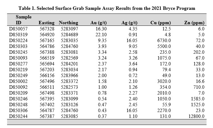
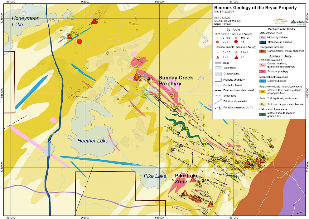
Figure 3. Bryce Gold Property Surface Geology Map with Grab Sample Assays
2021 LiDAR Interpretation Report
In 2021 Northstar commissioned Ronacher McKenzie Geoscience (“Ronacher McKenzie”) to complete a structural interpretation with data from a LiDAR survey flown at the Bryce Gold Property by KBM Resources Group in May, 2019 and a publicly available Abitibi Supergrid aeromagnetic TMI dataset. The LiDAR survey has a relative topographic vertical accuracy of 15 cm or better and an aggregate pulse density of 6 pulses / square metre, providing a dataset of high vertical accuracy, including a 1 m bare-Earth DEM, as well as LiDAR point cloud tiles and mosaiced orthoimagery. A number of filters and products were applied to the TMI to highlight different aspects of the underlying geology and were used as inputs to the structural analysis.
Several major, northeast-trending structures were delineated through LiDAR and magnetic data interpretation in the northern and western part of the Property (Figure 4). The southern area appears to be covered by overburden, which made the delineation of features more difficult. Smaller scale, north-south trending lineaments were observed in the northern part of the Property. Northwesterly lineaments, consistent with regional trends, were also observed.
Based on the structural interpretation of the LiDAR and regional magnetic data and historic exploration on the Bryce Gold Property, additional exploration is warranted, including prospecting, sampling and mapping along the major northeast-trending fault (“PVE Fault”) and in particular its splays as delineated by the structural interpretation (Figure 4). Structural mapping and sampling is also recommended in the Honeymoon Lake area along a northeast-trending porphyry dike.
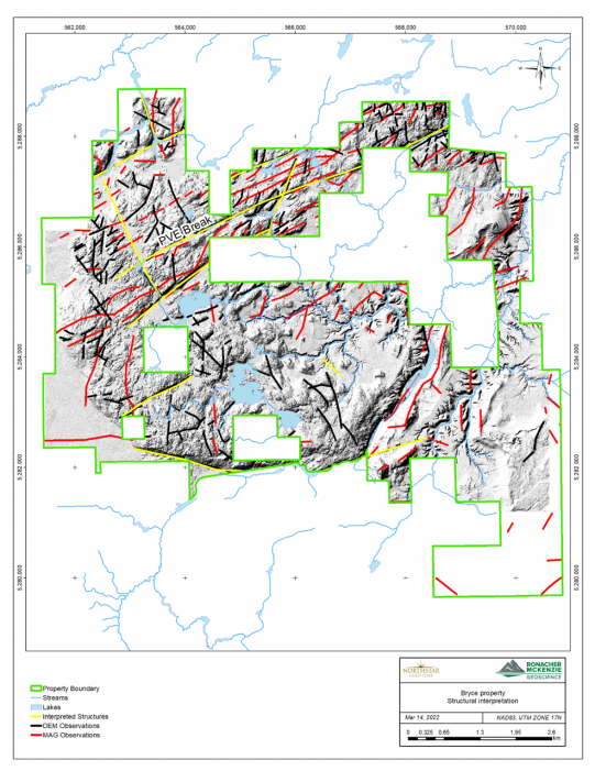
Figure 4. Interpreted Structures on Bryce Gold Property in yellow based on Lidar (black) and magnetic (red) observations. Bare Earth DEM in background.
Quality Control
Samples collected in the 2021 surface exploration program were delivered to ALS Global in Timmins, Ontario for preparation and assayed for gold by ALS Global in Vancouver, British Columbia.
Northstar has implemented a quality control program for its Bryce Gold Property to ensure best practice in the sampling and analysis of the surface samples, which includes the insertion of blanks, duplicates, and certified standards into the sample stream.
Surface samples were submitted to ALS Global at their Timmins, Ontario facility for sample preparation where the entire sample was crushed to better than 90% passing 2mm, 1kg riffle split and pulverized to 95% passing 106 microns. Pulps are forwarded to ALS Global in Vancouver, British Columbia for analyses. Gold analyses are obtained via industry standard fire assay with ICP finish using 30 g aliquots. For samples returning greater than 10 g/t gold follow-up fire assay analysis with a gravimetric finish is completed. Based on initial fire assay gold indications as well as visual indication of mineralization and alteration, intervals are selected for re-assay by the screen metallic fire assay method. Samples are also analyzed for 48 trace and major elements by ICP-MS following a four-acid digestion. ALS Global are ISO/IEC 17025:2017 accredited (Lab No. 579) for the preparation and analyses performed on the Miller Gold samples.
Qualified Person
Trevor Boyd, PhD, P.Geo., a ‘Qualified Person’ (Q.P.) as defined under Canadian National Instrument NI 43-101, has reviewed technical aspects of this news release.
About Northstar Gold Corp
Northstar’s primary exploration focus is the advancement of the Company’s flagship, 100%-owned Miller Gold Property, situated 18 km southeast of Kirkland Lake and Agnico Eagle Mine’s Macassa SMC gold mine. The Company’s strategy is to develop a material (+1 million ounce) mineral resource base to support a stand-alone mining operation at the Miller Gold Property.
The Miller Gold Property shares several important geological similarities with Kirkland Lake District gold deposits, including a similar style and age of gold-telluride mineralization, similar aged rocks and interconnected First Order controlling structures (Catharine Fault at Miller) off the Kirkland / Cadillac Larder Breaks. The premise is that gold-telluride mineralization at the Miller Gold Property is tapping the same magmatic gold source as the Kirkland gold deposits, which have produced over 25 million ounces of gold from 7 mines over the past 100 years.
Since going public by IPO in late 2020, Northstar has spent >$4 million in exploration at Miller, resulting in the discovery of a series of broad, shallow dipping sheeted quartz-gold-telluride vein structures in the Allied Syenite (Allied Syenite Gold Zone) and Planet Syenites and numerous +100 gram/metre drill hole intercepts.
During the period of August 7th – November 4th, 2021, Northstar completed an enhanced surface stripping, mapping and sampling program targeting near-surface gold mineralization over the Allied Syenite, No. 1 Vein and other areas on the Miller and recently acquired adjoining Searles Patent. In November, 2021 the Company announced the completion of a 14-hole, 2,495 metre Phase IIB diamond drill program at Miller targeting expansions of the Allied Gold Zone, twinning a number of historic No. 1 Vein drill holes on the Searles Patent and drill testing the newly discovered Area E mineralized zone 450 metres west of the Allied Syenite.
Recent 2021 drilling has more than doubled the surface expression (>350m X 200m) of the Allied Syenite Gold Zone, which remains open along strike and at depth. As a precursor to a Mineral Resource Estimate and for reporting purposes, the Company has commenced work to formally document the Allied Syenite Gold Zone as an Exploration Target in Q2 2022. This will provide the Company and investors a conceptual tonnage and gold grade range at the Allied Syenite Gold Zone and provide basis for continued expansion drilling and mineral resource development.
Northstar has 3 additional 100%-owned exploration projects in northern Ontario, including the recently acquired 1,200 ha Rosegrove Property situated 0.5 km from the Miller Gold Property, the 4,650 ha Bryce Property, an intrusive-gold / PME VMS project located along the projected east extension of the Ridout Break, and the recently expanded Temagami-Milestone Cu-Ni-Co Property located in Strathcona Township. Northstar is advancing all 3 properties to enhance geological understanding and optimize monetization opportunities.
On behalf of the Board of Directors,
Mr. Brian P. Fowler, P.Geo.
President, CEO and Director
(604) 617-8191
bfowler@northstargoldcorp.com
Cautionary Note Regarding Forward-Looking Statements
This news release contains certain forward looking statements which involve known and unknown risks, delays, and uncertainties not under the control of Northstar Goldcorp. which may cause actual results, performance or achievements of Northstar Gold Corp to be materially different from the results, performance or expectation implied by these forward looking statements. By their nature, forward looking statements involve risk and uncertainties because they relate to events and depend on factors that will or may occur in the future. Actual results may vary depending upon exploration activities, industry production, commodity demand and pricing, currency exchange rates, and, but not limited to, general economic factors.


